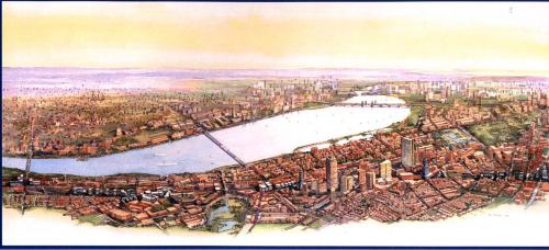
A Civic Vision for Turnpike Air Rights
Location: Boston, Massachusetts, United States. City
A Civic Vision for Turnpike AirRights in Boston, Massachusetts
This project creates a plan for Air Rights development over the turnpike which has torn through the center of Boston for many years. Perhaps best expressed by juror (and Bostonian) Robert Campbell, this project is "...remarkable for the process, in which a very diverse group of stakeholders with radically different perspectives came together, over time, to agree on a document that has been adopted by the City as a template for future development."
The Massachusetts Turnpike and adjacent rail lines cut a two-mile long, 300-foot wide canyon through the heart of Boston, dividing historic neighborhoods, creating uninviting windswept bridges, and bringing pollution and noise literally to the doorsteps of thousands of Boston residents. While building over the turnpike on air rights has been a longstanding public goal, air rights development during the 1960s and 1980s — without the benefit of a comprehensive planning strategy — did little for the city’s urban design.
Planning for good urbanism on the site was a complex task, requiring a vision for 44 acres located in eight distinct Boston neighborhoods. A 26-member Strategic Development Study Committee combined forces with a multi-disciplinary consulting team led by urban designers and including transportation, real estate, and environmental experts. Over the next 18 months, the redevelopment authority and the consultants managed an intensive citizen-based planning effort, coordinating over 25 public meetings involving more than 1,000 participants.
In addition to adding over 2,000 housing units to a city with an average 1% vacancy rate, the plan provides urban design standards such as scale, massing, active street-level uses, streetscape, streetwalls, integrating historic compatibility, and innovative design. The plan's Vision and Guidelines also address citywide initiatives such as improving transportation links, increasing affordable housing units, adding well-placed useable open space, and creating sites for community facilities. The plan calls for:
• Replacing more than 2 miles of highway bridges with sidewalks lined with retail and active uses connecting Boston neighborhoods.
• Creating 4-6 million square feet of new mixed-use development space in a city with little remaining developable land.
• Establishing over 2 acres of new parks and more than 10 miles of new sidewalks lined with pedestrian-friendly activities.
• Open opportunities to bring over $2 billion in private investment into the city center.
Finally, the plan is informed by core principles that are intended to shape air rights development across the length of the Turnpike and in any future economy. This ensures that future building will continue to respond to primary needs illustrated in the original planning effort: to reinforce the quality of life in adjacent communities; to enhance Boston as a place to live, work, and invest; to repair and enrich Boston's public realm; and to foster increased reliance on public transportation.
Project: A Civic Vision for Turnpike Air Rights in Boston, Massachusetts
Site: Air rights above the Massachusetts Turnpike, extending from the Allston/ Brighton neighborhood to Chinatown. These 44 acres are located in eight distinct neighborhoods in Boston.
Vision: New mixed-use development with the express goal of enhancing Boston as a place to live, work, and invest. Included are 2,000 units of housing, 3 new parks, 2+ miles of new sidewalks, new cultural and entertainment facilities, and a research campus.
Architect/ Planner: Goody, Clancy and Associates
Public Agency/ Developer: Boston Redevelopment Authority
Engineers: Vollmer Consulting
Other Consultants: Leff Consulting
Other Consultants: Economics Research Associates
Transect Zone(s): T1 preserve.
Status: <Unknown>
Project or Plan's Scale: City
Total built area (in sq. ft.):
Total project cost (in local currency):
Retail area (in sq. ft.):
Office area (in sq. ft.):
Industrial area (in sq. ft.):
Number of hotel units:
Number of residential units (include live/work):
Parks & green space (in acres):
Project team designers: Goody, Clancy and Associates
Project team developers: Boston Redevelopment Authority
Previous site status:
Starting/Ending date of construction/implementation: -


