Connecting the City of Water to its History
Location: Castellamare di Stabia, Italy. Seaside Italian city known for hot springs and archeological sites
The submission reflects the efforts of a graduate urban design studio, offered as part of an architecture curriculum, participating in an international, multi-school effort to enhance transportation interconnectivity and increase access to significant archaeological sites in several cities surrounding the Bay of Naples in Italy. In September 2005 four American and four Italian universities participated in a one week analysis and design charrette to identify potential urban design, planning, and preservation projects to improve the region. Teams made up of students and faculty from participating universities were paired up and assigned one of five towns to analyze. At the end of the week, the combined teams prepared and presented material to the conference, detailing perceived challenges and opportunities for urban design efforts in those communities. Teams then dispersed to return to their universities to use the experience for individual student design responses which were then re-presented to Italian government officials and charrette participants in December of 2005.
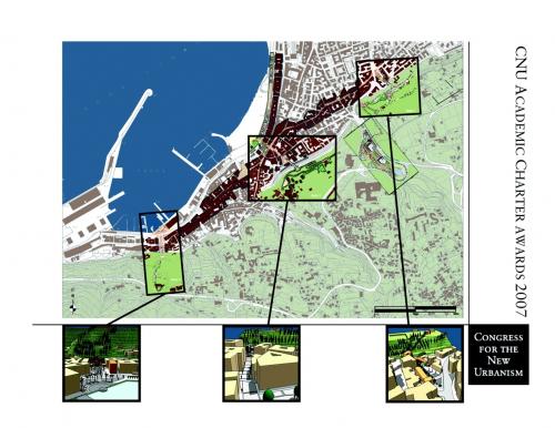
The assignment addressed by the project encompassed in this submission requested a proposal for connections between water travel, train travel, and the archeological and cultural sites located around a small city known for its natural springs. The city seeks ways to increase alternative transportation connections to possible heritage tourism sites found a top a plateaus above the main core of its urban development. The student team analyzed the current and future transportation alternatives to these sites and explored the relationships between the sites, the historic and modern core of the city, and the city's waterfront. The project proposes interventions for the city addressing local as well as regional scales, suggesting local connections and conditions while solidifying the city as a regional hub or center for arrival from the sea. The creation of vertical connections serves as the core of three proposed strategic interventions that link the historic city, the train line, and the regional, water-based transport system at the closest point between teh systems.
The work was produced over the course of about 12 weeks, with one week spent in pre-charrette analysis on campus, one week spent on charrette in Italy, and the remaining time doing the design work back on campus.
Project Description:
The interventions for the city address both local and regional scales, suggesting local connections and conditions while solidifying the city as a regional hub or arrival point from the sea.
The connection to the water and the Bay of Naples is the unifying element that gives this city its character. Roman and modern villas dot the landscape along the base of Monte Faito while ship-building enterprises and a water-based economy stretch along the impressive waterfront, the Lungomare. Water is the univeral theme, in its proximity to the sea and its many mineral springs.
The city suffers from a lack of vertical connections between the horizontal expanses of the modern cityh and the upper city higher in the foothills. Today the vast hillside on which reside the seven known Roman villas, along with the adjacent spa complexes, enjoys no direct connection to the historic city and port.
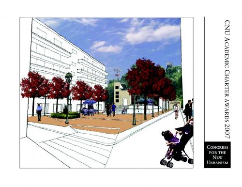
The creation of these vertical connections serves as the core of the three proposed strategic interventions. The first, located at the Piazza LIbero d'Orsi (at the intersection of the Via Nocera and Viale Eurpoa), suggests a new train station and neighboring public plaza, with a funicular/elevator that conducts visitors up to a piazzale over-looking the bay and Mount Vesuvius. A fountain at the western edge of the piazza provides the visual link to the city center and a symbolic connection to the water.
The current central train station becomes the locus for a vertical connection to the hillside and the thermal spas, while a reorganization of the public square creates a direct visual link to the waterfront and a clear procession into the city for new visitors.
The final intervention revives and transforms the existing Piazza della Fontana Grande from a ruin into a vibrant celebration of the "waters of the city." A restored fountain and plaza create a grand gateway to a new station for the Circumvesuviana, thereby linking the historic city, the train line, and the regional, water-based transport system at the closest point between these systems. A tourist arriving from Amalfi or Capri may there disembark, move through a spectacular new public space, and make a short connection to Stabiae, Pompeii, or any of the other tourist locations along the train line.
Transect Zone(s): T4 general, T5 center.
Status: Proposed
Project or Plan's Scale: Corridor
Features: Civic buildings & parks, Rail/fixed guideway transit.
Total built area (in sq. ft.):
Total project cost (in local currency):
Retail area (in sq. ft.):
Office area (in sq. ft.):
Industrial area (in sq. ft.):
Number of hotel units:
Number of residential units (include live/work):
Civic uses (type and size): public plaza, transit station(s)
Parks & green space (in acres):
Project team designers: University of Maryland studio, Assoc. Prof. Matthew Bell
Project team developers: NA
Previous site status: Redevelopment
Starting/Ending date of construction/implementation: -


