Design Guidelines for Emory University’s Clifton Community Partnership

Location: Atlanta, Georgia, USA. Suburban infill.
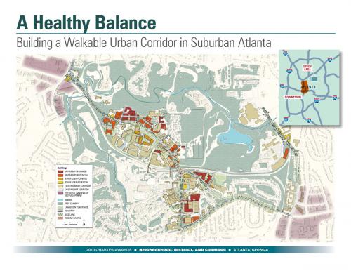
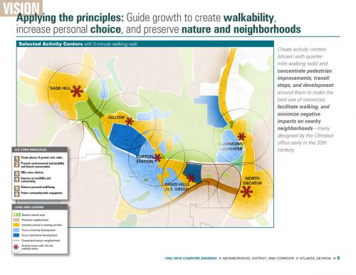
Recognizing that traffic from Atlanta’s regional growth was strangling quality of life, a major university convened a collaborative partnership (“the Partnership”) as a platform where the university, residents, civic and business leaders, and local governments could explore ways to work together to improve the area within three miles of the university’s core campus. The Partnership focuses on four key concepts: Live Locally; Walk Anywhere; Alternative Transportation; Enhance Vibrant Neighborhoods.
Olmsted‘s office laid out a plan for Druid Hills, the neighborhoods south and west of campus, that evoked the spirit of the City Beautiful movement. Graced by a network of parks that line streets whose curves celebrate the area’s hills and streams, the heavily wooded residential neighborhoods are highly sought addresses. Over the years, however, intersections of arterial streets have become strip shopping centers, and the narrow winding streets are today choked with heavy traffic. Moreover, the metropolitan region is expected to add another million people by 2025, roughly one-fifth of who are expected to settle in this quadrant. The number of cars on local roads and the number of hours lost to congestion have grown even faster than the population.
Burgeoning population, traffic, and wealth together have created a sort of perfect storm that has grown steadily since the mid-1980s. While much of the physical framework that Olmsted imagined has weathered this storm and remains visible and treasured, the quality of life he hoped to foster faces serious threat:
• Clogged streets and strip shopping centers create a sense of isolation rather than community;
• Roughly half of those who work in the community (the university, its hospitals, and the National
Centers for Disease Control are the major employers) drive to lunch regularly, rather than walk;
• Few dining or shopping options are within reasonable walking distance;
• Younger faculty/staff seeking to live nearby and older residents seeking to retire in their neighborhood
are priced out of available housing choices;
• Auto-dominated corridors without sidewalks make walking or bicycling impractical and deadly; and
• The forest canopy, woodlands, and streams so loved by everyone in the community suffer from the
polluted runoff from acres of surface parking that have spread across the landscape.
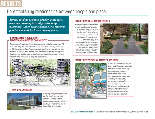
Creating higher density housing and mixed use projects in appropriate locations—aging strip shopping centers, for instance—was a logical choice. Yet, fear of development and density fostered watchdog civic activists, wary politicians, and risk-avoidant developers, all loath to work together. Fear of widened roads stymied thinking about transforming auto-choked arterials into walkable boulevards with bike lanes. Choosing not to surrender to the negative impacts of growth, the Partnership emerged as a key player to bring about civic learning, collaboration, and the momentum to work together for needed change. But first people had to trust one another. The vehicle: an urban design framework and guidelines created together. Hundreds of residents joined university faculty, staff, and students, representatives of other institutions, elected officials, and other stakeholders in an energetic process of developing and articulating a shared vision for the community, then created guidelines that address the unique characteristics and contexts of ten distinct enhancement areas, recognizing the important needs of surrounding neighborhoods and natural areas. Their active involvement in a year-long process—including participation in a broadly representative advisory committee, community workshops, a visioning charrette, community meetings, and a page-by-page review of the guidelines—forged a depth of commitment and mutual good will on which the community can build. All involved have praised the strength of collaboration around enhanced urban design features and walkability as a highly desirable benefit from well-placed and well-designed denser development. All perspectives now see opportunity in redeveloping two significant grayfield areas into transit-oriented mixed-use community centers.
Lessons learned: An affiliation of institutions and community residents was able to create a vision and guidelines responding to problems stemming in part to a vacuum of political planning leadership, and in the process earn the respect and collaboration of new county elected leaders and staff who wish to integrate the guidelines with the zoning code. Even deep divisions among community members were significantly bridged through engaging people of diverse opinions in a process of constructive public dialogue. State transportation policies famous for their emphasis on auto-oriented solutions are beginning to show flexibility around transforming traffic-focused roads into community streets that are also places for alternative access modes, signature landscaping, vigorous community activity and expression of identity. Major institutions in the study area have different leadership cultures that dramatically affect how well institutional actions match institutional missions.
Transect Zone(s): T1 natural, T3 sub-urban, T4 general, T5 center.
Status: Plan Approved
Project or Plan's Scale: District
Features: Affordable/subsidized housing, Civic buildings & parks, Mixed uses, Transit oriented development.
Land area (in acres): 200
Total built area (in sq. ft.):
Total project cost (in local currency):
Retail area (in sq. ft.):
Office area (in sq. ft.):
Industrial area (in sq. ft.):
Number of hotel units:
Number of residential units (include live/work): 3000
Civic uses (type and size): Pedestrian- and bike-friendly streets; neighborhood retail; existing high school; educational and medical institutions
Parks & green space (in acres): 20
Project team designers: David Dixon, Goody Clancy
Project team developers: Clifton Community Partnership (Client), Kittelson & Associates, Dovetail Consulting
Starting/Ending date of construction/implementation: 2011 -


