Innovista Master Plan
Location: Columbia, SC. Downtown area of southern US state capitol
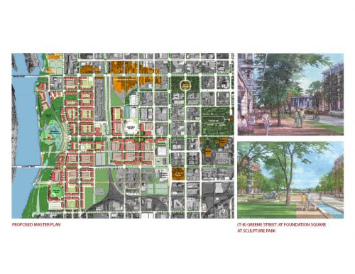
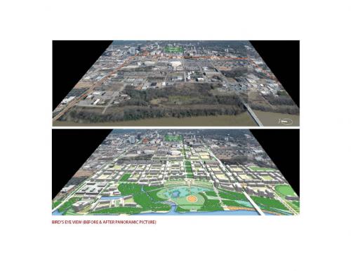
The submission is a proposed new mixed-use, live/work urban district located in the downtown area of Columbia, South Carolina, the state capital. The 500-acre site lies between a wide river on the west and a downtown University campus, the State Capitol complex and the city's central business district to the east. Historically an industrial mill site related to waterborne transportation and power generation, the area is at present underutilized with vacant property, large commuter parking lots, light industrial uses and small suburban-style office buildings.
The proposed plan is a unique opportunity to bring to fruitition a town plan drawn up just after the American Revolution. In addition to large ownership by the University, a substantial portion of the land is controlled by one of the City's leading families. In fact an ancestor of the present-day owners laid out the City in a precise grid of 400 squares in 1786. While the scheme does not replicate the grid exactly, it uses it as a conceptual armature. The combination of such a large amount of land under the control of the same family for so long, and their determination to see it developed properly, makes this an historic opportunity to celebrate the City's and State's rich architectural and urban history.
A Time-Tested Urban Scheme Suited to 21st Century Economics
Goals of the plan include the creation of an urban lifestyle within the downtown area in order to: retain University graduates and to attract the "best and the brightest" to live and work in the City; foster continued economic development of downtown; and provide a location for the University to develop major research facilities in connection with the transfer of intellectual property and technology from its research activities in the fields of environmental science, biotechnology, fuel cells, and nanotechnology.
Land use within the district will transition from University related research and academic uses on the east to a combination of offices, housing, supporting retail uses and community facilities to the west. Market analysis indicates that as much as 8.5 million square feet of mixed-use development can be accomodated within 15 years. Preliminary cost estimates for public improvements for new roads, bridges, pedestrian ways and the waterfront park total approximately $114 million.
A River Runs By It
The plan extends the historic grid through the district across rail lines to the proposed Waterfront Park, where it will be received by a new parkway that traces the edge of the bluff that overlooks the river. The grid system is focalized around a main east-west avenue which serves as the principal pedestrian spine leading from the heart of the University and downtown. Through a series of new public spaces, including a shaded urban square supporting mixed uses around it and a sculpture garden, the spatial procession terminates in a dramatic public overlook on the river that steps down as a series of flowering terraces.
A Plan of Action
A Waterfront Steering Committee has been formed to coordinate the work of two entities: an existing non-profit park-focused organization anticipated to be "sponsor" for the receipt of public funding the waterfront park; and an existing community development corporation that will take responsibility for implementing the mixed-use development. The City is currently drafting a new zoning ordinance to support the proposed plan. History shows that a substantial investment in the public realm, through parks and supporting infrastructure, sets the stage for private development that can be both transformational and economically viable.
Read more at this project's website. Transect Zone(s): T5 center, T6 core.
Status: Proposed
Project or Plan's Scale: District
Features: Civic buildings & parks, Mixed uses, Transit oriented development, Waterfront.
Land area (in acres): 500
Total built area (in sq. ft.):
Total project cost (in local currency): 114
Retail area (in sq. ft.): 850
Office area (in sq. ft.): 2
Number of hotel units:
Number of residential units (include live/work): 2390
Civic uses (type and size): baseball stadium (5000 seats)
Parks & green space (in acres): 83
Project team designers: Sasaki Associates, Inc.
Project team developers: NA
Previous site status: Redevelopment


