The New Wyvernwood - Boyle Heights Mixed-Use Community
Location: Los Angeles, California. Just outside of metropolitan core
Overall Design Intent:
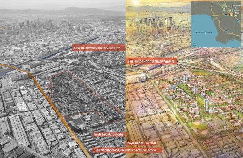
Located in an historically under-served area, the Site is envisioned as a cohesive and sustainable mixeduse neighborhood with a well-defi ned hierarchy of blocks and streets and a distinct community identity. The Project will provide for a walkable, diverse community composed of rental and home ownership units as well as neighborhood-serving retail, office, and civic uses, in an expansive green network of parks, playgrounds, courtyards, and pedestrian paseos – all within 3 miles of Downtown Los Angeles!
Existing Conditions
The site is currently occupied by a circa 1938 garden apartment complex, the notable aesthetic qualities of Garden City style in which the existing development is built, arising from the arrangement of the buildings in the landscape. The central Mall is the organizing element, around which the Site is designed. Consistent with the Garden City polemic, the existing street pattern is disconnected from the surrounding neighborhood. At present only seven streets provide access to the Site’s interior out of nineteen street intersections along the property’s perimeter. This configuration with buildings on six superblocks has had unintended consequences such as:
- Inhibiting access through the Site’s interior by emergency personnel and residents alike
- Limiting view corridors through blocks
- Making buildings difficult to identify and locate for visitors, deliveries, and policing
- Creating many small, narrow open spaces that are perceived as neither public nor private and hence under utilized or neglected.
- Creating potentially unsafe conditions, due to a lack of “eyes” on public space
Public Space
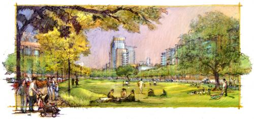
The Public Space Plan emphasizes access. Neighborhood parks are situated next to existing neighborhoods to the north; linear parks along Glenn help people fi nd the Central Park in the heart of the Site. The Central Park, which is faced by buildings to encourage safety, provides various passive and active recreation options to serve the larger community while preserving a majority of the site’s heritage trees.
The Plan provides a robust system of interconnected Open Space areas and through streets that:
- Provide an armature for connecting existing urban corridors to larger systems of public Open Space, including the nearby Los Angeles River and Hollenbeck Park
- Allow development at the Site to contribute holistically to a greater Boyle Heights
- Provide safe, publicly accessible recreational opportunities in the under-served community
The Central Park consists of an expansive open lawn area flanked by shade trees, a linear “Arroyo Walk” and a civic plaza functioning as an outdoor community patio. The park lies adjacent and perpendicular to the primary retail street off ering public gathering opportunities and a place for a variety of events, such as summer concerts, farmers markets and festivals.
Program
With the population of Los Angeles County projected to rise 37% by mid-century, seamlessly blending density into existing neighborhoods is paramount. Each block in the site will have a “min|max” scenario with blended densities, a mix of uses and unit types (residential, low income for-rent, senior housing, workforce for-sale housing, market for-rent and forsale, offi ce/retail/fl ex space, and community-serving uses. In total the plan provides of up to 4400 units including 660 aff ordable units as well as 300,000 square feet of offi ce and retail space and 25,000 square feet of civic space.
Streets
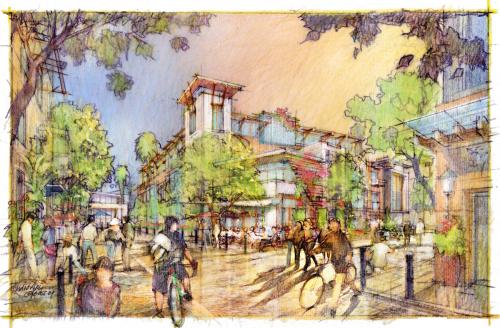
The plan provides for a hierarchy of streets rewoven back into the fabric of the Boyle Heights neighborhood. The diff erent street types are integral to the design of the Site. Their intent is to increase connectivity and access within the Site, provide multiple routes, accommodate various modes of travel and various development typologies along their lengths depending on their character, width, design, and amenities. With agreement from LADOT, public streets shall be no greater than 36 feet curb to curb including parking on both sides. Private streets will be narrower than this, in some cases, including streets that are 20 feet.
Response to Charter Principles
In the composition of a cohesive neighborhood framework that celebrates the ever-evolving history and culture of the local community, the plan is guided by the nine Principles that guide the development of the Neighborhood, the District and Corridor.
PRINCIPLE 10
Over 4 years, the urban design team has conducted a week-long on-site community design charrette, several week-long tenant outreach programs, over 50 individual stakeholder meetings, and a continuous public agency engagement program. The result is a plan that reconnects to an existing neighborhood.
PRINCIPLES 11, 14 & 15
4400 units of new housing (660 of which are designated aff ordable rental units) and 300,000 square feet of neighborhood serving offi ce and retail pepper the 70 acre site, turning the new housing into “home” and the new spaces into “places.” This project is designed as a fragment of a larger neighborhood: that connects to the metropolitan area via Olympic Boulevard, a major East-West corridor, that is linked to the City by 8 separate transit bus routes with 500+ boardings a day, and that sits in walkable proximity to the new Boyle Heights Gold Line Metrorail station.
PRINCIPLE 12
In an area that was severed from the rest of the Boyle Heights community by the construction of the 5 and 60 freeways, repair is needed. Restored street systems and circulation patterns turn edges into seams, knitting disparate blocks back together. These new connections will allow for at least 50% of the residents to be within a 1/4-mile walk distance from 500+ bus loadings and unloadings per weekday; thus, residents who do not own a car will have access more job opportunities within the greater Los Angeles area.
PRINCIPLE 13
The program includes up to 4,400 dwelling units with 660 of them designated aff ordable. The units will include rental and home ownership and will occur in a range of building types from town house to fl at to high rise. A form-based code assures at least two and sometimes three building types per block. A phasing plan allows for all residents who choose to stay on site during and after construction to be accommodated.
PRINCIPLE 16
Two existing elementary schools (one with a community recreation center) sit at either end of the site, and a new civic building with up to 25,000 square feet is provided in the center of the plan, knitting the existing neighborhood to the north of the site with the proposed redevelopment.
PRINCIPLE 17
Implementation of the plan is assured with a FormBased Code that among other things provides for mixed housing types per block, assures walkable streets and spaces, and is calibrated to each block face.
PRINCIPLE 18
A centrally located large park and three active park spaces allow for the recreational activities of the larger community. Playfi elds at either end of the central “green” provide residents a connection to the two elementary schools in the vicinity. Finally, smaller neighborhood greens at the northern edge of the project site tie the new neighborhood to the surrounding community
Canons of Sustianable Architecture and Urbanism
Located on the site of blighted and poorly conceived garden apartment style community, the plan proposes to triple the existing density, and diversify the land uses all within 3 miles from downtown Los Angeles. Within the redeveloped site, a tightly composed network of streets will relink with the surrounding community, The street sections are scaled to the pedestrian on foot. Their implementation is assured by a form-based code. A carefully crafted edge along Olympic Boulevard, a major East-West corridor in Los Angeles, will encourage pedestrian access to the eight bus lines that serve the area providing access to jobs locally and throughout the region.
The public realm includes shaded park spaces (with preserved heritage trees) designed to accommodate storm-water infi ltration with a bio swale that forms part of an “Arroyo Walk.” Courtyard building fronting these spaces will be required to have openings facing the prevailing breezes to allow natural ventilation and cooling of these courtyards and the units that front them.
The Mixed-Use Neighborhood Redevelopment Plan provides for a diversity of unit and density types as well as a range of aff ordability. Residents will be able to walk to locally serving retail including a grocery, store as well as to two adjacent schools, and existing regionally scaled retail off -site. Parking ratios have been reduced to 1.25 space/unit (from the standard 2.0 of LA zoning) and have been de-coupled from units themselves (they are not directly linked with a tenant or home owner) allowing further reductions in parking in the future if warranted. Existing roadway and building materials will be ground and reused for roadbeds where feasible. With the expectation that changes in Health Department Buildings will soon allow for greywater re-use, buildings will be required to be plumbed accordingly.
The plan includes also includes a detailed list of required and optional techniques and practices to conserve water and energy, minimize stormwater run-off , and conserve resources, all of which is governed by a checklist, included as part of the Specifi c Plan submission. Individual builders will have to show compliance with this rigorous list before a permit will be issued.
Lessons Learned
Historically, Los Angeles has developed a de-facto attitude towards building that puts the object first and leaves the space around it as an afterthought. This results in an iterative urban experience where one building may bear little relationship to its neighbor and the space between provides no framework for synergistic evolution.
The proposed project conceives the public realm first, establishing a robust system of interconnected parks and through-streets that a) provides an armature for connecting existing urban corridors to larger systems of public open space, including the nearby Los Angeles River and Hollenbeck Park, b) allows the development to contribute holistically to a greater Boyle Heights, and c) provides safe recreational opportunities in an under-served community.
The nearly 1.3 mile green space network, of which 0.6 miles is a linear park, preserves the amount public open space now at the existing site and reconfi gures it as a ring, showcasing those elements that have made its Garden City plan memorable, such as its heritage trees, the sweeping streetscape of Glenn Avenue, and the expanse of The Mall, while eff ectively precluding its many downfalls.
Five principles governed the design:
(1) an interwoven public re-engagement process;
(2) the physical repair of the urban grid and the creation of pedestrian friendly streets and public
space;
(3) the remixing of existing uses and the infusion of new program;
(4) the seamless integration of the redeveloped neighborhood with the surrounding built fabric and the environmentally sustainable design strategies to ensure the continual renewal of ecological life cycles, and most importantly;
(5) the assurance that tenants have a guaranteed opportunity to return. The new project proposes a paradigm shift in
the way Los Angeles conceives its public space, accommodates population growth, and integrates sustainable design practices. The increase in density is consistent with Mayor Villaraigosa’s aspiration toward a more elegant and livable density in the city of Los Angeles. Finally, the proposed mix of active uses, new through-streets, walkable neighborhoods, open sight lines, and clearly delimited public and private boundaries provide a safe environment for families and businesses.
Total project cost (in local currency): $2 billion
Retail area (in sq. ft.) : 100,000 to 200,000 sq ft
Office area (in sq. ft.): 100,000 to 200,000 sq ft
*See other credits listed below*
Transect Zone(s): T4 general, T5 center, T6 core.
Status: Proposed
Project or Plan's Scale: Neighborhood
Land area (in acres): 70
Total built area (in sq. ft.): 5500000
Total project cost (in local currency):
Retail area (in sq. ft.):
Office area (in sq. ft.):
Number of residential units (include live/work): 4400
Civic uses (type and size): Civic Building: 25,000 sq. ft.
Parks & green space (in acres):
Project team designers: Torti Gallas and Partners, Inc. Architects and Planners; Melendrez Design Partners, Landscape Architects; Studio Yves, Perspective Renderings,
Project team developers: Fifteen Group
Previous site status: Redevelopment
Starting/Ending date of construction/implementation: - 2020


