Planning Abaco
Location: Great Abaco Island, The Bahamas. Southern portion of Island
The community of Great Abaco Island (also known as "Abaco") obtained the services of the design team with the purpose of preparing a comprehensive proposal that advances sustainable strategies and principles of planning, urban design, and architecture. In general, the project was intended to promote the restoration of a sustainable settlement tradition on Abaco. Specifically, the project includes a collection of town planning principles for The Bahamas, a SmartCode calibration for the region of South Abaco, and architectural proposals for affordable, multi-family, attached and mixed-use building types. The project also includes an array of urban design or planning proposals that intend to illustrate sustainable practices as in the context of the region, greenfield development, infill development, suburban retrofit, and informal urbanism (shanty towns).
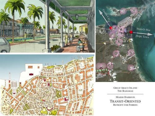
Settled in 1783 by English loyalists from the United States, Abaco exemplifies many of the typical contemporary planning and development problems found throughout The Bahamas. With a total estimated population of about fifteen thousand, Abaco is located approximately 180 miles east of Palm Beach, Florida and is characterized by many of the benefits and disadvantages of a tourism economy. The principal city and transportation hub is Marsh Harbour (official population approx. 5,300), which is characterized almost exclusively by conventional suburban strip development and significant informal settlements (shanty towns) occupied by illegal Haitian immigrant workers. From here, most visitors quickly take the local ferries to move on to the beautiful and thriving historic settlements on the Abaco cays, such as Hope Town and New Plymouth. A major purpose of this project is to build on the lessons provided by these historic communities, in which the settlements themselves are the resorts. Increasingly, contemporary resort development is segregated from where Bahamians live and work, which exacerbates the problems of suburban sprawl and threatens the long-term sustainability of the culture, economy, and natural environment of communities such as Marsh Harbour. The project includes suburban retrofit strategies for Marsh Harbour, as well as a long-term plan for the improvement of its principal shanty town.
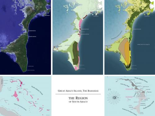
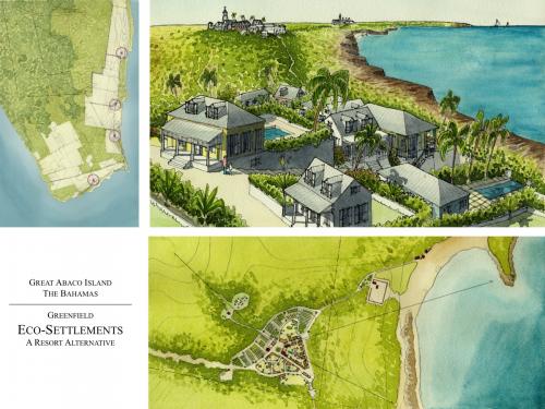
Much of the project focuses on the region of South Abaco (approx. 120,000 acres), the boundaries of which coincide with a political administrative district. South Abaco features the largest continuous expanse of undeveloped land in The Bahamas, some of which is being considered for conventional sprawl and resort development. The majority of the land is owned by the Bahamian government. It also includes a national park that serves to serves to help protect Abaco Parrot - a genetically unique and endangered species that lives only on Abaco. A handful of small coastal communities depend on some of the world's best fishing grounds which thrive in the immediate proximity of both deep ocean water and shallow tidal banks and mangroves. A major purpose of the project is to provide a planning framework for the region of South Abaco in order to determine what type of development ought to be located where. This regional plan has been proposed using the SmartCode-based sector planning model and responds to environmental conditions, water resources, landownership patterns, existing infrastructure, and population centers. Furthermore, in an effort to simultaneously protect critical species habitat and provide greenfield development opportunities for entitled property owners, the project proposes off-grid eco-settlements in the environmentally most sensitive areas of the region.
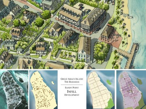
The chief settlement of South Abaco is the fishing community of Sandy Point (population approx. 500), which was first settled by emancipated slaves but is defined largely by conventional ranch construction. A significant proportion of the residents commute daily for at least one hour each way to Marsh Harbour or the outer cays, and local civic leaders are pushing to create more local jobs and build local schools. Sandy Point is constrained by water and mangroves on all sides, so recent efforts by the government have included a disconnected conventional single-use subdivision in an effort to provide developable land. This project proposes an infill development strategy for Sandy Point and this new subdivision (called Sands Cove) in an effort to advance the existing community, its close-knit culture, and its sport-fishing and tourism economy.
This project was commenced through a ten-day public design charrette which took place on Abaco. During this time, students engaged local citizens and officials in order to identify local growth patterns, places for preservation, available resources, and desirable as well as feasible growth strategies. Furthermore, the charrette team collaborated with local engineers, environmental groups and experts, the national park agency, human rights advocates, developers, and New Urban practitioners in order to realistically evaluate the charrette work. Planning, design, and architectural solutions were drawn and frequently presented for evaluation by citizens and local officials. Students worked closely with local property owners and residents. Following the charrette, the design team revised and refined all aspects of the proposals in accordance with the overall goals set at the charrette in collaboration with the community. Part of this work includes appropriate architectural solutions for affordable, multi-family, attached, and mixed-use buildings.
Transect Zone(s): T1 natural, T2 rural, T3 sub-urban, T4 general, T5 center.
Status: Proposed
Project or Plan's Scale: Region
Features: Affordable/subsidized housing, Mixed uses, Transit oriented development, Waterfront.
Land area (in acres): 120000
Total built area (in sq. ft.):
Total project cost (in local currency):
Retail area (in sq. ft.):
Office area (in sq. ft.):
Industrial area (in sq. ft.):
Number of hotel units:
Number of residential units (include live/work):
Parks & green space (in acres):
Project team designers: The School of Architecture, Andrews University - Student Designers, Illustrators, and Code Calibrators: Peter Biskupski, Bryce Buckley, Kayno David, Michael Figueroa, Kevin Fresse, Christos Hardt, Amanda Harrell, Lionel Johnson, Kystal Kaiser, Richard Kanjira, Takishah Michel, Hector Ontiveros, Diana Pastor, Jane Peeks, Joseph Pellegrino, Christopher Perry, Devin Phillips, Christina Pierson, Brian Reeves, Andrew Rellora, Arturo Rodriguez, Kevin Rosado, Sondra Ruffner, John Schaaf, Aaron Steen, David Surmann. Faculty: Andrew Von Maur, Troy Homenchuk. Charrette Visiting Critics: Jaime Correa, Jennifer Garcia, Kenneth Garcia, Stephen Mouzon, Sandy Sorlien
Project team developers: The School of Architecture, Andrews University
Previous site status:
Starting/Ending date of construction/implementation: -


