Feature...

CNU 23DALLAS/FORT WORTH 4/29-5/2/2015»»» The Saucier Town Plan
Submitted by JonZirkle on Thu, 03/08/2007 - 5:57pm
Tags for this project:


Location: Saucier, MS. Rural unincorporated Mississippi community threatened by significant growth and sprawl
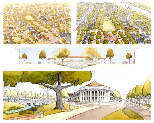
With funding from a regional planning and development district, the local county zoning office obtained the services of the design team to prepare a town plan and SmartCode overlay district for Saucier, Mississippi, a small rural unincorporated community of about 200 residents located 20 miles north of Gulfport, Mississippi. Saucier is along a major US highway, which in addition to relocation trends caused by dispersed victims of Hurricane Katrina, puts the community in the path of sprawl as county-wide sewer service could enable rapid development.
Organized citizens and county zoning officials are preparing for the population increase, beginning with the Mississippi Renewal Forum. Early in 2006, a university (not affiliated with this submission) was commissioned to produce a community plan for the greater Saucier region. It's broad strategic plan, prepared in part through a public charrette, identified the following as a preferred growth strategy for Saucier:
1) Preserve the majority of rural land in the area using SmartCode-based sector planning tools.
2) Channel significant future growth into a compact town in keeping with the Charter of the New Urbanism.
3) Provide an urban design proposal for such a town to be sited at or near the former lumber town.
4) Start by planning a town center development on a specific piece of property put forward by a local developer.
The strategic plan found significant community and county zoning office support, which sponsored this project. However, the zoning office did not support the broad adoption of the SmartCode as a regional planning tool. Instead, it commissioned the team to propose a local overlay district with limited regional coverage. The final regulatory proposal was made by a student team who callibrated a SmartCode template, though a local citizen association had considerable input.
The project was commenced through an eight-day public design charrette which took place in Saucier. Students worked closely with local citizens, property owners, officials, the local DOT and New Urban practicioners for input and charrette evaluation. The goals of the design team and the charrette results were compared and refined to create a plan that integrated varying sources of input and features of local heritage.
A final review of the work in Saucier is still pending.
Read more at this project's website. Transect Zone(s): T3 sub-urban, T4 general, T5 center, T6 core.
Status: Proposed
Project or Plan's Scale: Town
Features: Bus transit, Civic buildings & parks, Mixed uses, Transit oriented development.
Land area (in acres): 400
Total built area (in sq. ft.):
Total project cost (in local currency):
Retail area (in sq. ft.):
Office area (in sq. ft.):
Industrial area (in sq. ft.):
Number of hotel units:
Number of residential units (include live/work):
Civic uses (type and size): parks, plazas
Parks & green space (in acres):
Project team designers: Andrews University Urban Design Studio, Asst. Prof. Andrew von Maur
Project team developers: NA
Previous site status: Undeveloped infill
Starting/Ending date of construction/implementation: -