Feature...

CNU 23DALLAS/FORT WORTH 4/29-5/2/2015»»» The SmartCode
Submitted by Joe Menard on Wed, 02/11/2009 - 5:10pm
Tags for this project:
Location: United States and Abroad. Anywhere
About this Code and Manual
The Code is a unified development ordinance that incorporates the principles of Smart Growth and New Urbanism. The Manual has been assembled to assist those who are considering calibrating and adopting this Code for a city, region, or project. It presents the entire Code with comprehensive annotations and other supporting materials.
The Code, as presented in this volume, is a model ordinance. It is not persuasive or instructive like a guideline, nor is it intentionally general like a vision statement. It is meant to be law, precise and technical, administered by municipal planning departments and interpreted by elected representatives of local government. As a model code to be calibrated, it should be customized to regional character by urban designers, planners, civil engineers, architects and landscape architects, ideally with the participation of the local citizens. The Code must also be adjusted to comply with local law by land use attorneys.
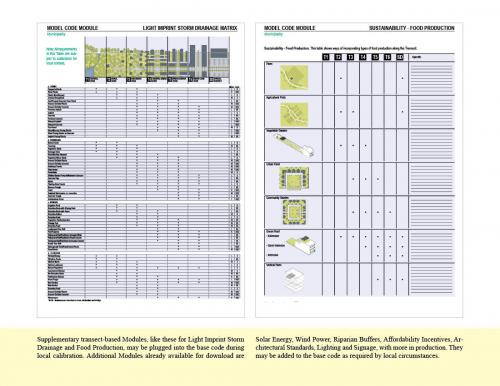
Because this Code envisions intentional outcomes base on known components of urban design, ti has always been a more streamlined and efficient document then most conventional codes. This version of the Code is based on the advice of experts from nearly two years of use in the field since the previous version. The base code is now shorter and simpler. Certain sections now appear as option Modules, including several Sustainability Tables. They are available to supplement the base code during customization. Because they are numbered by their correct place in the base code, they are easy to insert.
This Code and Manual also includes an extended Appendix offering sample plans, step-by-step procedures, illustrations, historical commentary, checklists, and resources. One particularly useful section is a submittal document for a greenfield project.
The Annotations and Appendix support the Code, but are explanatory and advisory only. They are not legally binding and must not be included as part of the Code itself when it becomes law.
What this Code does
-It utilizes a type of zoning category that ranges systematically from the wilderness to the urban core.
-It enables and qualifies Smart Growth community patterns that include Clustered Land Development (CLD), Traditional Neighborhood Development (TND), Regional Center Development (RCD), and Transit-Oriented Development (TOD.
-It integrates the scales of planning concern from the regional through the community scale, and down to the individual lot and, if desired, the architectural elements.
-It integrates the design process across professional disciplines
-It integrates methods of environmental protection, open space conservation and water quality control
-It integrates subdivision, public works, and Transfer Development Rights (TDR) standards
-It provides a set of zoning categories common to new communities and to the infill of existing urbanized areas.
-It is compatible with architectural, environmental, signage, lighting, hazard mitigation, and visibility standards.
-It establishes parity of process for existing and new urban areas.
-It integrates protocols for the preparation and processing of plans.
-It encourages the efficiency of administrative approvals when appropriate, rather than decision by public hearing.
-It encourages specific outcomes through incentives, rather than through prohibitions.
-It specifies standards parametrically (by range) in order to minimize the need for variances.
-It generally increases the range of options over those allowed by conventional zoning codes.
-It is freeware and open source, to be locally calibrated. The annotated Manual guides this process.
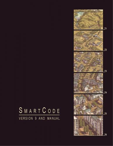
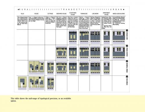
Transect Zone(s): T1 natural, T2 rural, T3 sub-urban, T4 general, T5 center, T6 core, SD district.
Status: Complete
Project or Plan's Scale: City
Total built area (in sq. ft.):
Total project cost (in local currency):
Retail area (in sq. ft.):
Office area (in sq. ft.):
Industrial area (in sq. ft.):
Number of hotel units:
Number of residential units (include live/work):
Parks & green space (in acres):
Residential types: High-rise, Mid-rise/loft, Low-rise flats, Townhouse/rowhouse/maisonette, Semi-detached, Small lot detached, Large lot detached, Live/work.
Project team designers: Project Coordinators and Principal Authors: Duany Plater-Zyberk & Company, Center for Applied Transect Studies
Project team developers: Individual co-authors and contributors: Andres Duany, Sandy Sorlien, William Wright, Rachel Merson, Daniel Slone, Chad Emerson, Elizabeth Plater-Zyberk, Marina Khoury, Tom Low, Galina Tahchieva, Michael Watkins, Chester (Rick) Chellman, Richard Hall, Peter Swift, Eusebio Azcue, Francisco Garcia, Gustavo Sanchez Hugalde, Maria Mercer, Shannon Tracy, Matthew Lambert, Robert Alminana, Jeffrey K. Bounds, Jaime Correa, Ann Daigle, Laura Hall, Susan Henderson, Steve Mouzon, Nathan R. Norris, Mary Vogel. Publishers: Diane Dorney - The Town Paper, Rob Steuteville - New Urban News, Renee Brutvan, Copy Editor - New Urban News
Previous site status:
Starting/Ending date of construction/implementation: -