Street Smart: Streetcars and Cities in the 21st Century
Location: United States. NA
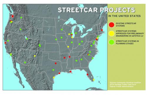
Reconnecting America, an organization dedicated to seeing more New Urban development accompanied by transit, self-published this book in 2007. The book demonstrates the power of streetcars, more than other forms of transportation, to promote compact, high-density New Urbanist development and high-quality pedestrian-friendly streetscapes. The book includes case studies of the most robust new streetcar systems and discusses in detail innovations in the planning, construction, and financing of projects throughout the U.S., the public-private partnerships that have helped get them built, and the developer agreements used to leverage significant public benefits including affordability, public space and parks. In efforts to achieve affordability and sustainability, making it possible to have no or fewer cars is ever more important; these stories about how communities with streetcars have promoted walkable, mixed-use, mixed-income neighborhoods and transit ridership and how the projects succeeded. The document aims to generate more streetcar projects and serve as a how-to manual including best practices. The manual includes chapters on the history of the streetcar projects as public-private partnerships; on "Planning for Private Investment and Pedestrians" (which excerpts a sample form-based code for a streetcar district); innovative financing strategies; economic development, and how developer agreements can be used to leverage public goals; system design, construction and operations; and case studies about recent projects in Portland, Tampa, San Francisco, Little Rock, and Kenosha, Wisconsin. Streetcars push the envelope of transit-oriented development due to the lack of federal funds, leading project promoters to innovatively utilize the private sector. Portland, OR is an excellent case study, and the book includes a plethora of statistics to support the defense of streetcar investment on a variety of levels. An important conclusion from studies in this document include research showing that land located near streetcar lines dramatically increases with development activity. The creation of this document was a public-private partnership and creatively financed, written and edited by a non-profit organization who promotes the public interest and financed by the for-profit engineering companies with a stake and expertise in this work. Unlike most transportation and land use policy publications, this document is visually appealing, filled with helpful illustrations, and laced with New Urbanist projects, easy for a busy elected official to peruse, quickly comprehend, and put to use.
Read more at this project's website. Transect Zone(s): T3 sub-urban, T4 general, T5 center, T6 core.
Status: Complete
Project or Plan's Scale: Corridor
Features: Affordable/subsidized housing, Rail/fixed guideway transit, Sustainable infrastructure, Transit oriented development.
Total built area (in sq. ft.):
Total project cost (in local currency):
Retail area (in sq. ft.):
Office area (in sq. ft.):
Industrial area (in sq. ft.):
Number of hotel units:
Number of residential units (include live/work):
Parks & green space (in acres):
Project team designers: Reconnecting America, Gloria Ohland and Shelley Poticha (editors)
Project team developers: Reconnecting America
Previous site status:


