Towards an Urban and Sustainable Puerto Nuevo
Location: San Juan, Puerto Rico. Original mass produced neighborhood of 1940s San Juan suburb
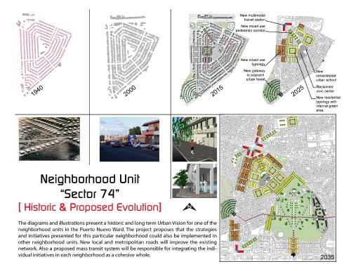
This project proposes a phased development of an old suburban ward in San Juan, Puerto Rico. This ward was the first mass-produced residential development in Puerto Rico dating to the 1940s. The project promotes improvement and enhancement of an existing development with greater urban land use efficiency. The project aims to revitalize the community and ensure greater sustainability while recognizing the existing original design's potential and bringing local residents intot he planning process.
The ward consists of 424 acres demarcated by avenues and formed by aggregate neighborhood units. The original design has several crucial oversights and shortcomings, including suppressing perpendicular roads that limit access to public spaces as well as limiting interaction between neighborhood units. These public spaces are shrowded with housing and primary schools, and local schools have absorbed space allocated for public space. Areas along main arterials have become densely packed with commercial activity at the cost of pedestrians. Population growth in the ward along with a significant increase in tenant occupation has put pressure on aging infrastructure, and overall quality of life in the area has been reduced.
The proposed redevelopment is based on several strategies geared to accomodate five times the existing population in a more dignified urban environment, increasing the current 11.2 u/acre to approx. 50-65 u/acre. The project also aims to deter the expansion of the suburban footprint, lessen car dependency, and increase a mix of uses in the ward.
Core strategies are as follows:
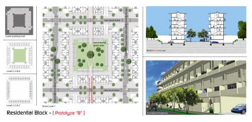
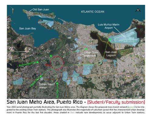
1) Implementation of a new multi-modal public transportation network linked to central public spaces by way of pedestrian corridors; 2) Recovery of the central public spaces by redeveloping schools in a new compact urban typology and liberating space for social purposes and underground parking; 3) Creation of connections among the neighborhood units within the ward and between the ward and surrounding city areas. This will be achieved by way of the construction of a series of streets (of different scales) for pedestrian and automobile access; 4) Incorporating the 400m pedestrian access radius as an elementary concept for the design and location of infrastructure, institutions, and service providers; 5) Restructuring urban parcels to accomodate new urban architectural typologies (mid rises) with a new 0.55 acre green area per block (20% of total block area); 6) Creating new commercial/business locales within the 400m radius to residential and or publicc transit terminals; 7) Integrating existing green areas and parks by means of a new bicycle/pedestrian network and a proposed boulevard; 8) Providing a variety of housing types and price ranges in order to promote a more plural composition of residents; 9) Integrating community residents into the planning and redevelopment process to avert gentrification, and ensure the creation of viable and just housing alternatives for temporary relocation or alternative housing options.
The project is inspired and informed by existing urban conditions, original neighborhood design (William Perry's paradigm), transit-oriented development, and Cerda's late 19th century mid-rise urban block prototype. The proposed residential unit typology is based on variations of architect Edward Larrabee Barnes' tropical duplex unit for multifamily developments characterized by cross-ventilation and facades as brise-soleil system as passive technology for climate control. Also, large openings at both facades provide excellent natural lighting and diminish the need for artificial lighting. A wood pergola and/or photovoltaic/brise-soleil panel system is optional for installation on the balconies.
Transect Zone(s): T3 sub-urban.
Status: Proposed
Project or Plan's Scale: Neighborhood
Features: Bus transit, Civic buildings & parks, Rail/fixed guideway transit, Sustainable infrastructure, Transit oriented development.
Land area (in acres): 424
Total built area (in sq. ft.):
Total project cost (in local currency):
Retail area (in sq. ft.):
Office area (in sq. ft.):
Industrial area (in sq. ft.):
Number of hotel units:
Number of residential units (include live/work):
Parks & green space (in acres):
Project team designers: Univ. of Puerto Rico School of Planning - Luis Enrique Ramos (architect & student); Gerardo Navas, Ph.D.; Miguel Antonio Lozada, VP
Project team developers: NA
Previous site status: Redevelopment
Starting/Ending date of construction/implementation: -


