University of Texas at San Antonio - Campus Master Plan
Location: San Antonio, Texas. A university campus
PROJECT DESCRIPTION
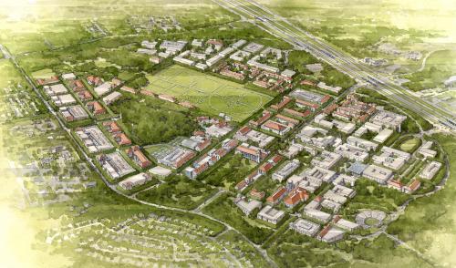
The University is sited in a picturesque landscape northwest of downtown San Antonio. The original Plan for the campus followed the 1573 Law of the Indies, the Spanish custom for the design of New World cities: A grand outdoor space is at its center, and pedestrian streets, called paseos, radiate out- ward to the north, east, south, and west to organize the site. Thus, although constructed in the 1970s, the original cam- pus core is very urban, with spare but human-scaled concrete buildings defining the central shaded Sombrilla Plaza. As the University has grown in subsequent decades, however, the clarity and compactness of the historic core has given way to a more suburban, disconnected environment.
Approach
The Campus Plan promotes density and compactness, and a vision of urban space as the primary means of campus con- nectivity. It establishes a framework to guide the massive growth that will be required to “right size” the campus for its current population of 28,500 students, to facilitate its goal of becoming a Tier 1 research institution, and to accommodate future growth to 40,000 students.
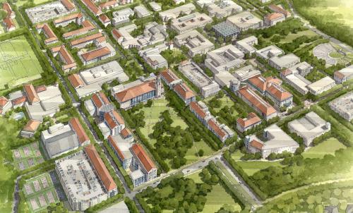
The campus civic structure defined by the Plan will guide that development: the Plan lays out an interconnected and varied network of campus streets and spaces, centered on the orig- inal campus core, and following the principles of the original design. It extends the original paseo concept of the historic core—strengthening existing axes with the placement of new buildings, and establishing additional axes relative to new public spaces—and it creates a major public gateway to the south with the establishment of a large, parklike open space.
Circulation, Parking, Utilities Infrastructure, Housing, and Wayfinding strategies were developed, along with architec- tural, landscape, and sustainability guidelines. A detailed analysis of existing campus accessibility was conducted, with recommendations for its improvement, both now and as the campus develops.
Process
The Plan is the product of a year-long collaboration between the planning team and the University. Together with the Uni- versity, the planning team developed several primary goals for the campus:
Implement a long-term strategy to accommodate more academic and research space.
Define open space through architectural and landscape design.
Provide a substantive structure for and variety of open spaces.
Provide for more on-campus amenities.
Improve campus circulation and clarify campus entrances.
Improve campus wayfinding.
Enhance transit within the campus and to existing transit resources.
Promote relationships with the surrounding context.
Implement a planning component and process to facilitate future campus expansion
Environmental Responsibility
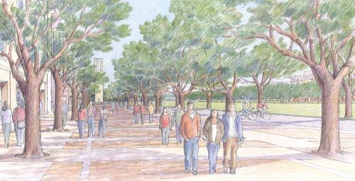
The University began as a commuter school but is rapidly be- coming a more traditional residential campus. The Plan will guide this transition so as to enhance the pedestrian experi- ence and minimize reliance on private vehicular transport. All new roadways will be tree-lined, with generous sidewalks separated from the street by planting strips to improve pe- destrian comfort and safety. The Plan establishes more ef- ficient inner- and off-campus shuttle systems linked to city transit routes. It encourages bicycle commuting, with recom- mendations for improved bicycle amenities, bicycle lanes proposed for major campus roadways, and connections to off-campus bike paths.
A major factor in the University’s current dependence on cars is the campus’s lack of an adjacent “Collegetown” to provide student amenities and enhance Collegiate life. The Plan pro- poses that an existing residential complex on the campus’s southern edge be replaced over time with a dense, mixed- use neighborhood that will include retail, commercial, and residential space.
Because much of the campus is located over an aquifer re- charge zone, the Plan includes a stormwater management strategy to protect water quality. The East Campus, currently undeveloped, contains areas designated by the U.S. Fish and Wildlife Services as “critical habitat” for karst inverte- brate species. Given the sensitivity of this area, the Plan plac- es the East Campus within the campus’s Green Reserve—a natural reserve for habitat protection and aquifer recharge. Sensitively sited hiking trails will enhance the area’s use as an aesthetic and environmental asset.
RESPONSE TO CHARTER PRINCIPLES
Many of the issues facing American college campuses are similar to those facing American cities. Campuses often have a dense core, organized on clear spatial principles and some- times densely built, surrounded by more recent low density construction organized on suburban principles and sprawl- ing into previously unbuilt natural areas. These campuses often suffer from the inefficient movement brought about by their sprawl, and as they grow, they tend to destroy the natu- ral areas that give them much of their beauty.
In spite of the numerous administrative and functional differ- ences between cities and campuses, the principles elucidat- ed in the Charter are remarkably applicable to the design of college campuses. Particularly pertinent to the design of this Campus Master Plan were Principles 3, 8 & 22, 18, and 19:
Relationship to agrarian hinterland & natural landscapes
The campus is located in a suburban area on the outskirts of a major city. Part of the campus is over an important regional aquifer. While the area has been subject to suburban devel- opment for about 40 years, both the campus and the sur- rounding areas still possess tracts of undeveloped landscape with natural vegetation and habitat for indigenous species (including endangered species). The Campus Plan desig- nates large areas of land as a “Green Reserve” to preserve the campus’s natural setting, protect the aquifer, protect habitat and habitat connectivity, and provide recreational and educational opportunities.
Transportation Alternatives, Automobiles, & Pedestrians
The plan establishes a hierarchy of streets, ranging from pedestrian streets — the “Paseos” — to primarily vehicular streets—the campus perimeter loop road.
The Plan recommends that the campus street system be made more coherent so as to provide vehicular connectivity in the less pedestrian portions of campus, and that the uni- versity shuttle bus system be strengthened to take advantag- es of this connectivity to provide an efficient campus route system. It recommends that the university shuttle system engage the city bus shuttle bus system. It proposes univer- sity bicycle paths that connect with the city’s growing bicycle path system, and that take advantage both of the densely occupied portions of the campus and the natural areas of the Green Reserve. The Plan specifies a range of street types for various levels and speeds of traffic. All include tree-shaded sidewalks, and all but the lowest speed streets include bi- cycle lanes.
Parks, Playfields, Conservation Lands
The public open spaces of the campus form the spatial ar- mature that will guide the growth of the campus. The larg- est open spaces—the playfields and the parks — define the campus edges and define and connect campus districts. Quadrangles form the centers of campus districts and neigh- borhoods. These spaces are linked by campus streets into a coherent whole.
The Physical Definition of Streets and Public Spaces
The Plan establishes the pattern of streets and open spaces for the campus. The streets — both pedestrian and vehicular, and the public open spaces — quadrangles, courtyard, play- fields, and parks — are designed and located to promote in- terconnectivity and to provide opportunities for shared use by faculty, staff, and students.
The open spaces vary in character from formal and geometri- cally ordered, to romantic and irregular. They range from the programmatic specificity of the intramural and athletic play- fields, to the busy pedestrian paseos to quadrangles that can accommodate an endless variety of informal uses and ac- tively programmed events, to the quieter hidden courtyards within academic buildings and dormitory complexes.
The pedestrian streets converge on the existing core of cam- pus — the “Sombrilla”. They are provided with sun shading devices and planted with shade trees. The plan includes guidelines for building facades that address the streets. These promote adherence to build-to lines, sufficient height to spatially define the street, and in inclusion of loggias as pedestrian amenities.
Lessons learned: The campus is located in an area predominately organized according to a suburban model, and with very few nearby examples of urban conditions. These factors would not bode well for the acceptability for a solution based on an urban paradigm. The design team graphically presented the issue of the need for the growth of campus facilities, and the potential reper- cussions of this growth for the form of campus and the quality of life there. The team successfully presented a vision of the potential benefits of density, of using urban space as the pri- mary medium of design, and of preserving open land. Even in a place with a strong culture of suburbanism, the campus administration was able to see the benefits of pursuing an urban model for their campus.
Transect Zone(s): T2 rural, T4 general, T6 core.
Status: Plan Approved
Project or Plan's Scale: District
Land area (in acres): 600
Total built area (in sq. ft.):
Total project cost (in local currency):
Retail area (in sq. ft.):
Office area (in sq. ft.):
Industrial area (in sq. ft.):
Number of hotel units:
Number of residential units (include live/work):
Parks & green space (in acres):
Project team designers: BGK Architects with Michael Dennis & Associates
Project team developers: N/A
Previous site status:
Starting/Ending date of construction/implementation: -


